Big Gee in Action


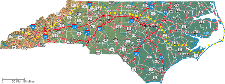
The adventure began in the first half of February 2007. My initial day of hiking was the 10th after an all night bus ride. The trail started on the highest sand dune on the east coast in Jockey Ridge State Park and finished on Clingmans Dome in the Smoky Mountains. I hiked east to west or in other words from the sea to the mountains. To me this seemed like the logical way to tackle the project but the guidebook and many other hikers start at the other end. Maybe they favor the generally downhill trend of walking to the sea. Me, I prefered to take the easiest terrain first and save the mountains for later. Also to my benefit is that the weather will start to warm by the time I enter the high country.

Hikewnc.info describes the MST like this.
North Carolina's longest trail, The Mountains to Sea Trail, is an ambitious project to provide a foot path linking the Mountains in the West to the Coastal Plain in the East. The trail, when completed, will be over 900 miles long. For now, sections of foot path are linked with roads and state bicycle routes. Starting at Clingman's Dome (the highest point in Tennessee and the Great Smoky Mountains National Park), traveling over Mount Mitchell (the highest mountain in the entire Appalachian chain), and through Jockey's Ridge State Park (the highest sand dune on the East Coast), this trail boasts many superlatives and includes sections that provide excellent day hikes in the Mountains area.
As usual I started out of season for the trek. This is a good spring or fall hike and I began in winter. Still I thought that I had a good plan except for the unplanned cold snap right at the start. I wasn't in the mountains until March, and I didn't experience any conditions that I hadn't already bested. One interesting note is that I was only the 11th person to complete the whole MST and the first out-of-stater. That's kinda cool. I am not certain how many of the other ten did it as a thruhike versus section hiking it over several years. Three thruhikers started in 2007 and I was the only finisher.
My return trip was a mystery for most of the trip. I hadn't wanted to finish hiking with the end of the trail nor did I know how I'd get to a Greyhound station. In the end I hiked north along the Appalachian Trail to Davenport Gap (Smoky Mountain National Park boundary) where I was graciously picked up by some Couchsurfers from Asheville. A day later I was in Asheville's bus terminal.
Because this trail is new and unknown there isn't a network of hiker resources yet. Accomodations were always a big question since hiker friendly hostels haven't sprung up like on the AT. Around Raleigh and Greensboro I was picked up and hosted by other MST thru and section hikers. In Asheville I made extensive use of Couch Surfing's TandemTravelers who put me up for well over a week and shuttled me all over. A special thanks goes out to them. In public lands I camped, and in towns I used a number of motels and hotels. At least half the time I asked and received permission to put my tent up on someone's lawn throughout the Piedmont and Coastal Plain. People of all types were very generous to me on this trip.
Curious how it went day by day? Start reading my daily journal! Or see a handy table of all my entries to date. I also used the trailjournals.com website to leave updates directly from the trail. Hardcore direct from the MST. And I used TrailJournals for my guestbook. View or sign my TrailJournal guestbook.