
Big Gee in Action


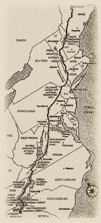
The Appalachian Trail is a 2,167.1 (circa 2000) mile footpath through fourteen states along the Appalachian Mountain chain stretching from Springer Mountain in Georgia to Mount Katahdin in Maine. In 2000, I and two or three thousand others attempted an end to end hike of the entire trail. This is a thruhike and those who do it are thruhikers. Since the first thruhike in 1948, only about 4,000 people have claimed to successfully hike the entire distance. This figure includes thruhikers and section hikers that have hiked the entire trail a piece at a time over the course of years until completing the whole distance. In 2000 the year of my hike only about 15% of aspiring thruhikers succeeded.
Physically, the trail is a simple footpath marked by white 2x6 inch painted rectangles known as blazes. The AT passes through deciduous and coniferous forests, moutains above and below the treeline, meadows, grassy bald mountains, and even swamps. Along the trail are various shelters ranging from the popular three-sided lean-to, to converted barns, to small cabins. At some points the trail goes directly through a town especially when it is necessary to cross a large river. Some parts of the trail like the Smokey Mountains and Shenandoah National Park receive very high usage by the public. Other sections like the "Hundred Mile Wilderness" in Maine are frequented by few.
Like most, I started in the south and hiked to Maine. Unlike most, I started very early. On 6 January 2000, a Greyhound bus dropped me off in Gainesville, Georgia and an outfitter's shuttle carried me to Amicalola State Park. I signed in at the park visitor center, hung my backpack on the traditional scale, and started hiking the approach trail to the AT's start on Springer Mountain.
I planned for a six month trek north and expected to finish a bit earlier, however, heavy ice and snow in North Carolina and Tennesee and resupply problems later on slowed me down. Total time on the trip was 6 wonderful months and 10 glorious days.