
Big Gee in Action


First thanks to those that have answered some of my questions and otherwise helped me plan this trip. They include Tamas Varga, high school friend and now Cali resident, PCT-l members who answered my JMT questions, David Dickey for his JMT journal and elevation data, and JamesJM for his JMT advice. And of course, thanks to those that wished me well.
Day one on the trail began 13 June 2003. Before and after, I stayed at the exellent Yosemite Bug Hostel. Naturally, my journal and trusty digital camera were present. I returned 03 July and started putting updates on the site immediately.
In short the 211-mile John Muir Trail (JMT) runs through California's Yosemite, Sequoia, and Kings Canyon National Parks, Devil's Postpile National Monument, John Muir and Ansel Adams Wilderness areas, and Inyo National Forest. From Happy Isles in Yosemite in the north to the summit of Mt. Whitney at the southern terminus the JMT showcases what is often called the most spectacular hiking scenery in the US if not the world. Indeed the JMT is internationally famous and attracts hikers from all over the world.
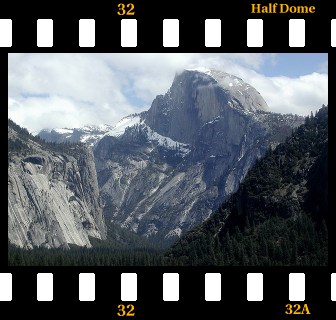
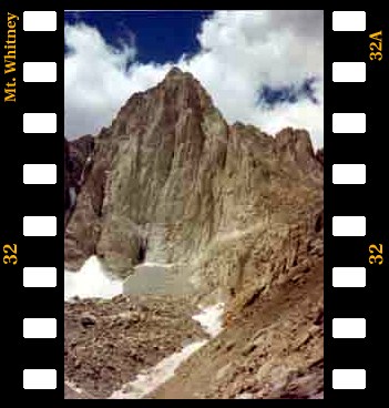
Near the northern end, a spur trail leads from the JMT to the top of Half Dome. Between Half Dome (8,842 ft) and Mt. Whitney (14,497 ft) the majority of the trail shares it's footbed with that of the mighty Pacific Crest Trail (Mexico to Canada). From the summit of Mt. Whitney, which is the highest point in the 48 contiguous States, 11 additional miles remain to Whitney Portal.
My journey was southbound. I arrived on the 12th of June to get my bearings and see Yosemite's Visitor Center. My permit was for 13 June - 03 July, but I planned on 12 - 15 mile days which meant I finished early. I enjoyed some ice cream and potato chips at Reds Meadow. There are geothermal showers available there as well. After that, I had one resupply in Vermillion Valley Resort.
I am started a little early for a John Muir Trail thruhike, however, ultra long distance thruhikers on the Pacific Crest Trail (2,600+ miles) began to arrive in force on their northward journey to Canada. They are very small number (about 300 per year) compared to Appalachian Trail thruhikers (2,000 - 3,000 would-be thruhikers) and were traveling in the opposite direction as me, but I got to share some camps with them.
Bears are a problem in this whole area, so I carried a 3 pound bear canister for my food and other scented items, but my only bear encounter was at Yosemite on day 1. And since I had to contend with snow at high elevations I had my ice axe. Besides those items I took just my normal backpacking gear.
I had no plan on how I was returning to my car. Fortunately I made the return trip in two easy hitches. Total mileage was about 225 miles. Thanks guys! My previous record goes to what was probably a 50-60 mile hitch in Mexico.
Curious how it went? Read my daily journal!