
Big Gee in Action


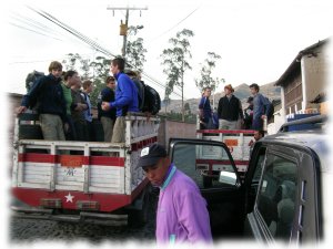
This group of 33 including leaders was exploring Ecuador for five weeks. Almost four of these had passed already and it was time for some mountaineering. Morgan, the owner of Moggely Climing, hired me as a guide to stay with the group over the next eight days. I had been to many of the places we would visit, already climbed 2 of the 3 mountains, and have decent enough Spanish so he felt I was a good choice for guide where certified mountain guides were not needed. There was a lead guide as well who's responsibility it was to fuck up the schedule too. For the acclimatization peaks of Imbabura and Pasochoa two additional certified mountain guides arrived for a total of four and we each had our own group of around eight to lead.
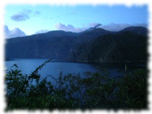
This first day was a full one with three major tourist destinations north of Quito. It was also the most messed up when the lead guide ignored the itinerary which started a cascade of problems. Mitad del Mundo has been mentioned here a couple times so I won't go into any more details. Cochasquí however has not been mentioned here before. It is the country's most important pre-Inca ruin consisting of 15 pyramids on a hillside at 3,100 m built by the Cara people as a solar and lunar observatory. I enjoy archeological sites and had been wanting to visit this one but I have to admit it was underwhelming. The flat topped pyramids were small and uninspiring. I also had the opportunity to showcase my bad Spanish as a translator for the museum guide. Afterward we made a quick stop at Otavalo's market. And lastly we arrived at Laguna Cuicocha (Guinea Pig Lake) at dusk. A few minutes earlier and we would have had fantastic sunset photos across the crater lake with it's two lava dome islands and views of Cotacachi (4,944 m / 16,216 ft). Instead we had a 1.5 hour night hike around part of the rim before leaving for a very late dinner.
Because we did not have much time at the market the day before we returned to Otavalo in the morning for everyone's buying pleasure. This is the place to get all of one's Ecuador mementos. I am sure the vendors were sad to see this group leave. I wish I had taken pictures of the 33 and all their purchases. Nor was I immune having picked up a few more items myself. We returned to La Esperanza and the welcoming Casa Aida before heading off for a couple hour hike to prepare for summitting Imbabura the next day.
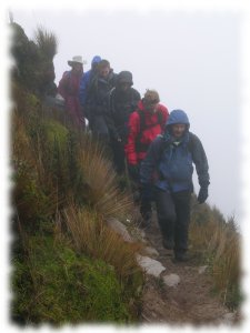
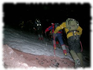
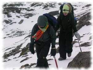
Where did the good weather go? This was a cloudy and rainy day. We started out in the morning from Hostal Casa Aida for the mountain in a collection of pick up trucks. It wasn't much more than an hour before we were in the clouds and drizzle. At one point the lead guide was considering turning around due to the weather. However it did not get any worse and we plodded ever higher. There were four guides including myself and we took our groups separately up the mountain. Surprisingly even with some cold, wet, and sometimes altitude sick hikers all groups enjoyed 100% success reaching the summit.
This was a rest day for everyone before heading south of Quito for two more climbs. On the way back we made a quick stop at Laguna San Pablo just outside of Otavalo. Still no real good views of Imbabura.
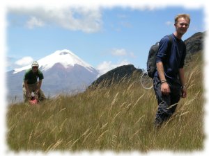
Now south of Quito, Pasochoa provided an easy hike and additional summit on the way to Moggely's new Hostel near Machachi. It is lower than Imbabura at 4,199 meters and only around a 700 meter ascent from the trailhead so it was a quick hike and everyone made it but not to the highest point. The lead guide thought that to get the whole group to the highest summit we would need rope. I disagree but that is his call to make. I know there were some that were disappointed to look over and see a point a little higher than then were. But that was quickly forgotten in the blistering heat of the hostel's showers.
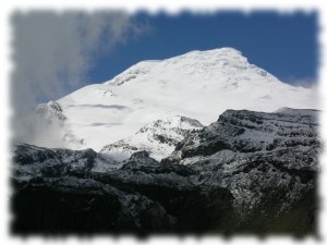
For logistical reasons the group was split roughly in half for the climb of Cotopaxi. Group 1 left for the mountain on the 28th while the remainder relaxed at Hostel Valhalla and ate good food.
 I stayed back with group 2 while the group leader and expedition doc went up to the climbers hut with the guides. I left the next day with group 2 and down came an exhausted group 1. Thirteen of sixteen summitted - very good. After lunch and swapping gear we hiked up to the hut. There was some crampon and ice ax familiarization to do before the 23:30 wake up call.
My responsibility was to follow the summit teams up to the glacier. It is about a 45 minute trudge. If between the refugio and 20 - 30 minutes on the glacier someone got sick, cold, or changed their mind. I was to lead them back down to the hut. Two of the group experienced an ephiphany on the first day's hike up to the hut and decided against attempting the summit. One of these accompanied me to the glacier with the rest of the climbers but otherwise I had nobody else to take back down. When I woke up some of the others had already returned. The lead group made the summit in a stunning 4:05. Amazing. Even the last group's time was still good. Congratulations to all that made it! Good luck on your future climbs.
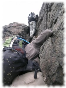
Due to shuttle difficulties it was 10 o'clock before we started hiking. In two pleasant hours we were below the large summit pyramid. Our choices were the standard route which takes a sandy slope up to the summit or the direct approach right above us. Taking the ridge directly to the summit is a lot more fun without the hassle of walking up sand but there are some long drop offs. Like true adventurers Chris and Chris chose to climb the crest despite the fact that the route was more difficult than anything they had previously attempted. I would rate the route as an unsustained class 4.
The route challenged their comfort level. But even the hardest parts did not prove to be much of an obstacle, and these two, with little experience climbing unroped with exposure, even made it through the crux without any drama. Our Options, Another View, The Crux. I believe it was there that "Death Route" and "Your parents are going to sue me" were heard though.
The drama began later that evening. Down in the cave, our refuge for the night, it became apparent that their sleeping bags were not going to be up to the task of keeping them warm - even with their legs inside their backpacks as well. And both were a little headachey. About three hours later, leader Chris began vomiting and an hour later we began descending to the connecting ridge to get down to a lower altitude. The plan was to continue along the traverse route and once past Padre Encantado drop into that valley to whatever altitude felt good. When I did it, it took maybe 45 minutes to arrive at Padre and that is what I foolishly told them. For us, in the dark, in clouds and driving snow, a sick walker, and only 1 headlamp for three people it was a grueling 4 hour ordeal. Everyone worked well as a team but we never dropped into the valley. Chris was feeling better although very tired, and I couldn't be sure which ridge was correct so we bivied there and waited for morning to descend which we did without too much hassle.
Fortunately the good overshadowed the bad and both Chrises really enjoyed the climb. Back at Moggely's the four hour night hike had already just become a funny story over some rum and cokes while student Chris was already planning on using my movies of the climb in his trip slideshow.
I stopped down at Moggely Climbing one day and Morgan asked if I wanted to do some guiding. "Sure. Sign me up", I responded. Then he starts telling me about the group of 33 British and the details of the 8 days he needs me for. I hadn't realized that he was serious, but who am I to turn down money for an all expenses paid trip concluding with two attempts on Cotopaxi? Okay it turned out that I didn't get to actually climb Cotopaxi past the glacier but I did bag Imbabura which I hadn't climbed before.
Not long after I was having dinner with the boys from Moggely, Annie, and Chris the leader of the British scout group. This scouts are from Cambridge so don't think it is a bunch of sniveling 11 year olds running around. Chris, who had stayed behind with a sick student while the rest went to the jungle, was asking about climbing opportunities to prepare themselves for Imbabura, Pasochoa, and Cotopaxi. One thing leads to another and I find myself leading a guided trip of my own - the Pichincha traverse.
Yes I got another extension on my visa. Only one more of those left. I'm still not sure what I am going to do. I would like to stay in Ecuador longer. I've heard conflicting stories about the fine for illegals. I guess I'll wait and see what happens to Stewart who is 4 months over and leaving soon.
I met with Annie from Iliniza Sur for talk of climbing over a movie and dinner. She couldn't find a place to burn her digital pictures to CD for me but hopefully she will be able to do so before leaving for points south. After dinner I joined some of the guys from Moggely Climbing at the bar. Little did I know that would lead to an all night fiesta of music and more with the cover band ending at Stewart's place above Guapalo. I finally left around 08:30 with Jerez for our neighborhood. No pictures from this event thankfully!
Our assault on Iliniza Sur was planned for Thursday. This mountain is hard to find partners for because of its difficulty. However, going through Moggely we were able to put together a 6 person team including 2 guides. This will be my first guided climb. I sure felt funny about that. But it was certainly a good group of people and I really respect Moggely. They are an excellent operator and lots of fun to hang out with. And considering that I probably would not be able to find partners for it myself, my choice was clear.
Note: This picture of Iliniza Sur on the right I took some time ago while climbing Iliniza Norte. Our route followed the righthand glacier up.
Wednesday our two teams went up to the hut. I had wanted to make another ascent of Iliniza Norte but by the North Face route this time since I was going to be right there. However it would have meant humping all my gear over the summit and by the time we got started it was a bit late in the day to be considering that. Plus it was very windy. I was really worried that the weather would mean yet another aborted mountain attempt.
The total climb is something like 1,400 meters and is broken approximately in half by the hut. Still the remaining 700 meters or so to the summit usually takes about 4 hours. For the curious we went with 2 rope teams; 3 people on a single line. The route is rated AD+, and we carried a second ax for the crux, a 20 meter wall of up to 70° ice. Most of the glacier was 50° and a general purpose ice ax was sufficient. The weather stayed nice and we had some views (lots of photos) but not from the summit. It is probably my favorite climb so far. The descent took 2 hours to the hut and 1 back to the vehicle.
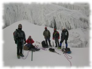
The group photo is our teams minus the camera guy, Thomas from Switzerland. That is me on the left. We stopped here momentarily to get ready to climb the ice wall behind us. Our route is off the right side where the wall was less featured. This is actually one half of a big crevasse. The other side slid down and out rather than split open so we climbed up to this snow bridge instead of down to it. Notice the hole behind the guy on the right.
After Iliniza Sur I headed to Moggely's new hostal, Hostel Valhalla, to do some work for them. It is new and in need of a website so I spent a night there and got plenty of pictures and started building the site.
Ellen checked her email just in time to join Liz, Mike, and I for an attempt on Carihuairazo. This mountain is a respectable if easy peak located next to giant Chimborazo (6,310 m / 20,702 ft). Because of this it is overlooked and infrequently climbed. Also it is a little hard to get to without private transport as we discovered.
We took the bus to Ambato far south of Quito and from there hired a pickup to take us to the trailhead. I believe his name was Jose and he was a very nice guy. Wasn't too sure where the trailhead was though. We got close and a local boy insisted we could reach the mountain from where we were although it did not match the description in the book. We were further away than we planned so we decided on an early 2 am start.
Well to make a long story short we made it to the foot of the mountain after some tiring hiking through the páramo. The problem was the mountain was completely hidden by clouds and without a visual reference we couldn't get our bearings. I believe we were at the start of the route but did not want to start climbing without being able to see so we waited for about an hour. With no change in the weather and no indication of a pending change we heading down into the valley on what was supposed to be a shortcut. It wasn't and we where quite tired by the time we arrived on the road and caught a bus.
Tim returned from Perú and had time enough for an attempt on Cayambe before flying out on Wednesday. It is the 3rd highest in Ecuador and has a bit of a dangerous reputation due to crevasses and avalanches but the Picos Jarrin route is rated PD and well within our abilities. I couldn't match Tim's acclimatization though. He had been trekking and climbing 5000 m peaks in Peru while I had only summitted four rather casual 4000 m peaks since Cotopaxi almost a month previous and had just spent time in low altitude Baños getting sick.
After a late 02h00 start Tuesday morning we left the hut and started up a steep, rocky hill. The wind was relentless. Negotiating the mixed snow and rock was slow but nothing compared to the other side of the hill where the glacier began. The wind was tearing down the mountain. Every five steps we would be knocked back one. Every step was a battle. The snow conditions, however, were excellent. The recent snowfall and wind loading had obliterated the crevasse difficulties leaving a beautiful unbroken snowfield up to the ridge. Naturally we were still roped together in case one of us should break through and fall into a crevasse.
Our turn around time was approaching more rapidly than the summit unfortunately. I was dragging above 5000 meters and we were both being pushed around something fierce by the wind. I remember seeing Tim stagger around during one gust like a drunk just trying to stay on his feet. It was exhausting. A little above 5,200 meters we sat down and decided to turn around. Here is a short clip that really does not do it justice.
As bad as that was it was nothing compared to the descent. Going down the glacier was not that big a deal but the rocky hill was something else. I was literally worried that I might be blown off the mountain. Really. At one point it felt like someone had grabbed my helmet with both hands and was pulling my head back and forth while I fought to keep my tripod stance (ice ax and two feet).